WELCOME TO WAIHEKE WALKS
This site was born in October 2010 & is evolving still . Starting off with general information, news items, photos and events the site is also a portal for the enjoyment of Waiheke's natural beauty. Expect to see some great Waiheke pics plus a guide to some excellent walks.
Scroll down for Waiheke photo slideshow plus click, zoom or drag the Google Map above to see the main streets of Waiheke Island and get a basic idea of the layout.
WALKING is THE best way to experience Waiheke Island, even though, due to terrain ( or lack of planning) the island lacks a dedicated linked coastal system. People who want to save time can walk straight off the ferry and be on a coastal or an inland walk within minutes. Medium to good fitness is recommended, along with a walking pole or fashioned stick, due to the abundance of hills and slopes that form the island terrain.
Oneroa Village sits at around 20 metres above sea level but you can find walking terrain up to 100 metres above Te Wharau Bay.
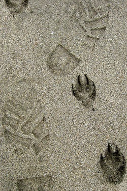
Dog walkers will be pleased to know there are excellent opportunities to walk coastal tracks.
A new walk has just opened (late December 2010)
A bit of a shameless promo for the vineyards - but those who want to combine both walking and wine can take in the Te Matuku Peninsula Track - which at 3kms long may exceed the tolerance of those who want a quick taste ( well catered for in the selections below)
This new track runs between the entry on Orapiu Road near Passage Rock Vineyards and the Poderi Crisci Vineyard on Awaawaroa Road. This opportunity opens up further the tranquil eastern end of the island. Expect to see some beautiful tree specimens as well as a harbour view .
Scroll down for Waiheke photo slideshow plus click, zoom or drag the Google Map above to see the main streets of Waiheke Island and get a basic idea of the layout.
WALKING is THE best way to experience Waiheke Island, even though, due to terrain ( or lack of planning) the island lacks a dedicated linked coastal system. People who want to save time can walk straight off the ferry and be on a coastal or an inland walk within minutes. Medium to good fitness is recommended, along with a walking pole or fashioned stick, due to the abundance of hills and slopes that form the island terrain.
Oneroa Village sits at around 20 metres above sea level but you can find walking terrain up to 100 metres above Te Wharau Bay.
Dog walkers will be pleased to know there are excellent opportunities to walk coastal tracks.
A new walk has just opened (late December 2010)
A bit of a shameless promo for the vineyards - but those who want to combine both walking and wine can take in the Te Matuku Peninsula Track - which at 3kms long may exceed the tolerance of those who want a quick taste ( well catered for in the selections below)
This new track runs between the entry on Orapiu Road near Passage Rock Vineyards and the Poderi Crisci Vineyard on Awaawaroa Road. This opportunity opens up further the tranquil eastern end of the island. Expect to see some beautiful tree specimens as well as a harbour view .
TWILIGHT RAMBLES 2011 January, Tuesdays from 6pm
featuring 11 January Te Whau, 18th Rangihoua, 25th Te Matuku. Sponsored by Auckland City, through Forest & Bird ph Brian 3727662 for details
FIRST OFF THE BOAT
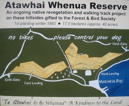
ATAWHAI WHENUA - "Kindness to the Land" - and Beyond
As per map (left) - exit the ferry wharf Matiatia, walk along beach-side pathway, enter track network at point marked West Landing. Take the lower or higher track to LEFT. Tracks all exit at East Gate. Gentle uphill through bush, birds, 25 mins.
East Gate is on Oceanview Road - the main route to Oneroa Shops & Beach. (5-10 mins)
Alternately - walk from West Landing uphill to West Gate on Nick Johnstone Drive. Continuing around coastal cliffs of the Matiatia south headlands for great views, though steep up and down sections: needs good fitness.Walk 22 mins on this route to reach Te Miro Bay junction.At West Gate: the short route to Te Miro Bay involves a road walk heading right, for 7 mins, enter track on left at sign, to reach Te Miro junction in 3.5 mins. Then for a loop, take the right (north) side coast route back to West Gate. At Te Miro Bay an extended coastal walk around isolated bays is on offer. Continue left (south) for 10 mins, easy up and down, to reach historic Church Bay.
Leaving the bay, walk uphill 8 mins to reach a junction. A steep uphill track to left returns to the road in 10 mins - Cable Bay Rd turn left here to pass vineyards & return to Matiatia or explore Oneroa - allow at least an hour.After Church Bay you can explore more bays by continuing on, up & down the coastal route for 10 mins. Take the uphill exit on left then down through bush, birds to cross over to Cable Bay in 10 mins. The road route back starts at Walter Frank Drive which climbs gradually to join Church Bay Rd
HOT TIP # 1
Walk off the ferry at Matiatia and if the tide is low, exposing the stony beach, you have easy access to a walk with great views. This one takes close to an hour, one way, and is accessed by walking to the LEFT of the ferry building - that means walking North, then in a left curving arc along the beach until the yellow capped track marker pole shows the entry point to climb to the headland. A moderate uphill climb then descends to Cable Bay. The final section, around 20 minutes, is a steep uphill before the track takes you to Owhanake Beach - not a top beach for swimming but great for dogs all year round. Many options are then on offer. You can retrace your steps back to the ferry if the tide is still low. You can proceed along Owhanake Beach heading North East, exit at right and locate the track marker poles leading to Island Bay beach, and the initially steep, hillside Fossil Bay walkway, rising to 40 metres which descends via vineyards to a quiet road, 12 minutes walk from the main village, Oneroa. Owhanake-Oneroa takes around 30 minutes.
HOT TIP # 2
NORTHERN BAYS + BUSH & RESERVE ROUTE
From MATIATIA Wharf, walk or take the Palm Beach Bus, to the Hauraki Road-Karaka Rd corner. TURN LEFT from bus stop, walk 20 metres or so down Karaka Rd on left to find the track entry for DON'S TRACK. Descending down wooden steps you enter a cathedral of native trees then meander down a peaceful, gentle bush track with dwellings secreted in bush. In 10 minutes you will arrive at tiny HEKERUA BAY, with a pebbly beach. Walk onto the right to ascend a hillside walkway heading east to SANDY BAY. In 6 minutes you will reach a viewpoint seat over the bay; a further minute downhill takes you to the small sandy beach. Further ahead, the level Great Barrier Road heading east takes you to ENCLOSURE BAY within 5 minutes, a small sandy beach with rocky outcrops. Opposite the beach, walk along Empire Road to enter the McKenzie Reserve, a regenerating plantation of tree species. Walk upwards via the first left track to reach impressive views on upper Great Barrier Road. Expect to take around 10 mins from the beach to the road exit. Then walk up the road, curving left to reach the main bus route - left towards Palm Beach or right side to go back to Oneroa or Matiatia.
From MATIATIA Wharf, walk or take the Palm Beach Bus, to the Hauraki Road-Karaka Rd corner. TURN LEFT from bus stop, walk 20 metres or so down Karaka Rd on left to find the track entry for DON'S TRACK. Descending down wooden steps you enter a cathedral of native trees then meander down a peaceful, gentle bush track with dwellings secreted in bush. In 10 minutes you will arrive at tiny HEKERUA BAY, with a pebbly beach. Walk onto the right to ascend a hillside walkway heading east to SANDY BAY. In 6 minutes you will reach a viewpoint seat over the bay; a further minute downhill takes you to the small sandy beach. Further ahead, the level Great Barrier Road heading east takes you to ENCLOSURE BAY within 5 minutes, a small sandy beach with rocky outcrops. Opposite the beach, walk along Empire Road to enter the McKenzie Reserve, a regenerating plantation of tree species. Walk upwards via the first left track to reach impressive views on upper Great Barrier Road. Expect to take around 10 mins from the beach to the road exit. Then walk up the road, curving left to reach the main bus route - left towards Palm Beach or right side to go back to Oneroa or Matiatia.
HOT TIP # 3
To ONEROA VIA KORORA
KORORA RESERVE on Korora Road is a key link between the west end-northern bays from Owhanake to Fossil Bay for walkers who are heading towards Oneroa Village & Beach. Some may chose the peaceful Korora Rd from Owanake, others will take the scenic coastal hillside track which exits further up on Korora Rd. The latter has more uphill climbing.
The whole loop from Owhanake-Oneroa shops-Owhanake can be done in an hour.
Owhanake to Island Bay 7 mins. Island Bay to Fossil Bay lookout 10mins. Fossil Bay Lookout to Korora Rd via vineyards 10mins. On Korora Rd walk uphill for 12 mins to reach Oneroa shops OR walk 5 mins to reach the Korora Reserve entry on left at 36 Korora Rd. Find the downhill track on right to reach the west end of Oneroa Beach in just over 3 minutes. Beach is shallow & accessible at most tidal phases. Pathways to Oneroa shops run uphill opposite the beach in 2 locations.
ONEROA EXPLORE
LITTLE ONEROA to Headland with Bush Return
You can walk the length of Oneroa Beach in 15 mins - but there's more - Little Oneroa Beach is at the east end through very interesting rocky outcrops, with little climbing at low tide. ( Climb the cliff track -end, right side, if sea level blocks the tidal route OR An easy cliff track is available - for elevated views - starting at the Beach Parade-Oceanview Rd corner and ending with downhill steps to Little Oneroa Beach: small sweet, sandy, with a shop for supplies.
From Little Oneroa find the uphill stairway at the east end of the beach. A steep climb for 4.5 mins to reach a viewpoint seat. Another 3mins, going down to sea level*. Next uphill, 4 mins, another seat viewpoint ( Newton Rd). Walk on through bush to headland for 3 minutes to find a picnic table and great Hauraki Gulf views: Rakini, The Noises, Little Barrier, Great Barrier Islands and Coromandel Peninsula can all be seen, weather permitting.
A steep stairway to sea level is an option at the left end of the headland.
Returning to the Newton Rd viewpoint, walk 7 mins up the road to find a track entry sign. This bush reserve is a treat, somewhat dense, but pole guides are adequate, an easy downhill refreshment on a hot day taking around 7 minutes to return back to the sea level* point reached earlier. Proceed left and uphill to return to Little Oneroa.
The complete loop easily done in an hour if in a hurry; allow 2 hours if you plan to explore, sit, have refreshments.
WOODSIDE SECRET
If you can get to Whakanewha Regional Park in the Rocky Bay area then a hidden treasure is around the corner.
From the O'Brien Rd corner of Onetangi Rd, proceed south to reach Gordon's Rd on right ( Rangihoua Olive Estate on corner) Gordons Road passes the regional park, beach and carpark. (This section is 3kms -5mins by car) Keep on Gordons Rd climbing up then down for 2kms to reach in 3 mins the Woodside Bay turnoff then beach as visible.
Two options: coast walk of 15-20 mins leads to a secluded bay with a long jetty. Medium-difficult flat terrain with pebbly, slippery surface, sharp oyster shells OR
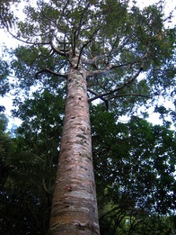
The stupendous bush walk featuring very old, large native tree specimens. Of particular note: the stand of regenerating kauri which is 5 mins from entry. Large karaka, puriri, pohutukawa, taraire and you will see many kawakawa, kohekohe plus many more specimens.
Easy up and down cliffside track which is currently under-maintained, in semi dense bush. A walking pole or stick is recommended. The walk takes 20 mins one way to the end of track sign, and requires return by retracing or 14 mins back along the pebbly beach at low tide.
On a hot day, this is a great shady walk before noon, especially with a low tide for beach access. Decent footwear a must.
SOUTHERN BAYS
ROCKY BAY area has lots of nooks and crannies along the southern coastline. This little walk can be easily accessed once you reach the hub of Rocky Bay/Omiha where buses have a terminal point ( corner of O'Brien & McMillan Rds) Walk west along McMillan, where you'll find a peaceful out-of -the-way beachside settlement facing Kuakarau Bay. There is easy access to the beach. At the far west end of the beach is a track entry. The bush track is easy-medium grade, leading to a collection of small bays including Te Akau O Hine and Hitapa Bay, during a 35 minute walk. Retrace back or extend your adventure further for at least another hour's walking : continue uphill for 7 minutes to reach Te Whau Drive. Turn right onto this road and walk to Vintage Lane on left. Go down this road to find a track entry which leads in 5 mins to small, quiet Okaka Bay. Continue to find track point leading uphill in 5 mins to Margaret Reeve Lane. This is an elevated roadside walk which meets the main route at O'Brien Road. Turning left here will lead back to the major road junction of Ostend & Onetangi Roads.
FROM RETRO to The Esplanade
Check out the Retro Walk around Oneroa on the RETRO page and consider your nearby extra option: use the Google map - top of this page to locate The Esplanade which runs along the Blackpool beachfront, heading right or eastwards to Surfdale Beach.
From December 1st 2010 the walk from the east end of Blackpool Beach to Surfdale Beach is a walker's and cyclists wonderland -though be aware dogs and horses are likely to join in the fun during this initial one year trial of a vehicle ban along this route.
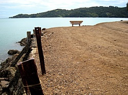
This walk is one to enjoy for several reasons, particularly being mostly level, though on a gravel surface. The photo depicts the one roadside seat, facing Auckland, at the point of a former ferry wharf, long since washed away
FINDING THE BALANCE

Waiheke has narrow winding roads. We don't want to add to the statistics. Let's aim toward safer, slower driving so that people can feel safe to walk, cycle & travel on horseback around the island
Let's create an environment that truly is different from any other beach resort.
Sorry Henry Ford, the car is NOT King.
Let's start walking

RETURN TO WAIHEKE NEWS HOME PAGE
